In the vast and ever-changing expanse of our oceans, accurate forecasting is essential for maritime operations. Amphitrite is harnessing the power of satellite data, real-time measurements, and predictive AI to deliver highly precise forecasts for the maritime industry.
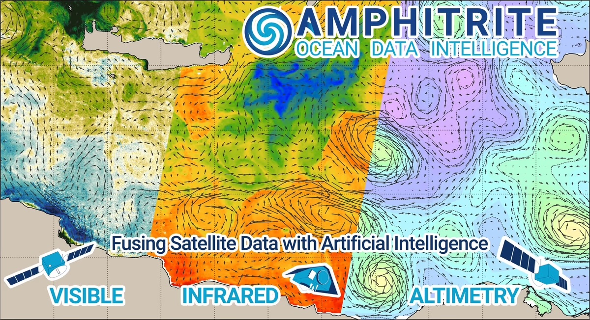
At its core, Amphitrite meticulously gathers ocean data from publicly available sources, primarily the European Space Agency’s (ESA), the National Aeronautics and Space Administration and NASA satellites, traditionally utilized for scientific research. This aerial perspective is then fused with “in-situ” measurements – data collected directly in the water by buoys, oceanographic vessels, or navigation data of commercial vessels, which record crucial parameters like ocean surface current, speed over ground, speed through water, wave height, wave period and other oceanographic information. This unique combination of satellite observations and in-situ data provides enough information to estimate a snapshot of the ocean’s state.

Illustration of Amphitrite’s technology
By merging these two distinct data streams, Amphitrite creates a robust and reliable foundation for its forecasting models. Furthermore, the platform leverages historical data spanning over a decade from the same data sources, establishing a massive baseline that informs how future ocean currents, winds, and waves might behave. This extensive historical context is where predictive AI modeling truly shines.
While industry giants like Google, Nvidia, Microsoft, and Oracle maintain massive, global climatology models – offering insights into long-term climate patterns and historical events – Amphitrite focuses on a more immediate and practical need for the shipping industry. The platform prioritizes high-resolution and high-accuracy forecasts over a week, a timeframe critical for operational decision-making.
The distinction between accuracy and resolution is crucial here. While a broad, low-resolution picture might provide a general sense of conditions, it lacks the precision required for safe and efficient shipping. Amphitrite excels by achieving both high resolution and high accuracy. This is accomplished by seamlessly integrating in-situ measurements with the exceptionally precise data from the latest generation of satellites, which offer unparalleled resolution and accuracy.
The sheer volume of data involved – terabytes upon terabytes – necessitates sophisticated processing. This is where AI and machine learning become indispensable. What once took a week of computation on a supercomputer now can be achieved in less than an hour, thanks to advancements in cloud computing and the accessibility of powerful processing capabilities from providers like Nvidia. This dramatic reduction in processing time is a game-changer, enabling Amphitrite to provide timely and actionable forecasts that empower ship captains to make informed decisions, optimize routes, and enhance safety at sea.
We sat down and interviewed Thomas Joyce, Director Global Business Development. Thomas, please share with us, where did the initial idea for setting up Amphitrite come from?
Thomas Joyce, Global Business Development director
From our work at the intersection of oceanography and AI. We saw a gap between what satellites and in-situ sensors can now observe in the ocean and what ship operators actually receive day-to-day. Amphitrite was founded to turn that rich but messy data into operational, current-aware guidance that measurably improves fuel use, ETAs, and workability.
What gaps weather companies weren’t addressing? What is Amphitrite’s USP?
Conventional routing often smooths out fine-scale current structures that actually move the needle on speed-over-ground. Our USP is high-resolution, current-aware intelligence with auditable before/after baselines–so savings and ETA reliability are both real and provable.
How does oceanography expertise differentiate you from general weather platforms?
We start from ocean dynamics–mesoscale/sub-mesoscale currents, fronts, eddies–and how they couple to ship power and motions. That domain focus lets us capture energy-relevant features others parameterize away, especially near coasts and in straits. This expertise also plays a part in the validation of our products, as many metrics derive from physical knowledge, such as distribution or Lagrangian drift evaluation. We also use multiple local models on regions with specific behaviors and show that they outperform global models.
Your models claim 2–3× better accuracy, 60% improvement, and higher resolution–what’s the breakthrough?
Three things together:
(1) cutting-edge AI computer-vision applied on multiple satellite observations to capture fine-scale motion providing high-resolution forecasts
(2) AI-model able to process rapidly the latest satellite observations providing better accuracy
(3) continuous improvements of our model based on independent validation with ship navigation data and in-situ data.
How are you leveraging SWOT data, and why is “first-to-market” valuable?
SWOT’s wide-swath altimetry resolves sea-surface height–and hence geostrophic currents–at unprecedented scales. We produced the first operational model that trained using this next generation data, in order to detect small features that materially change voyage outcomes.
What’s your approach to real-time data fusion and computation?
We pull in data continuously, update our models in small steps, use extra computing power when needed, and cache results close to users. That keeps the API fast and the onboard updates predictable.
Can you share specifics about fuel savings?
On current-influenced legs we typically see 5-8% fuel reduction with steadier ETAs; on some coastal corridors the savings can be higher. We always pair results with a hindcast baseline to keep them auditable.
Which segment is driving fastest growth, and why?
Commercial shipping under CII/EU ETS/FuelEU pressure – liners, Ro-Ro/ferries, tankers – because small percentage gains translate directly into cost and compliance wins. Defense users are also growing for navigation safety, acoustics, and comms planning.
What do you want to achieve in PortXL’s acceleration program?
Validate value on Rotterdam-linked lanes, secure at least one integration/pilot with a PortXL partner, and anchor local relationships to scale across North Europe.
How do you find the Rotterdam startup ecosystem?
Operator-centric and pragmatic–ideal for stress-testing products that must deliver measurable fuel, ETA, and compliance benefits quickly.
Who are the ideal customers you haven’t reached yet?
Operators with ≥10 vessels and good data hygiene who still rely on coarse metocean inputs; voyage/performance platforms wanting a premium ocean layer; and port/terminal teams that need physics-aware arrival windows. We also target any ship willing to reduce its fuel consummation and C02 emission thanks to precise current routing.
Which geographic markets are priorities?
North Europe (North Sea/Baltic/Channel), the Mediterranean, and the Gulf/Singapore corridors – dense traffic and strong compliance drivers – followed by West Africa and the Americas for current-heavy trades.
What partnerships/integrations are you most interested in?
Voyage management and fleet performance platforms, weather/wind-assist providers, and ETS/CII accounting tools that can embed our API to make their decisions ocean-aware.
Are you hiring in oceanography or AI?
Yes – applied oceanography, data assimilation, ML engineering, and Machine Learning Ops to scale the real-time pipeline.
How is the recent €1.2M funding being deployed?
~60% product/R&D (SWOT assimilation, current+wave coupling, API hardening), ~25% go-to-market (integrations, pilots), ~15% team.
Where is ocean data intelligence heading in 3-5 years?
To living, fused ocean twins – continuously refreshed from space and sea – used not only for routing but also autonomy, regulatory reporting, and port/terminal planning.
How do you see the shipping industry in ~15 years – and what is Amphitrite’s role?
Voyages will be co-optimized across currents, weather, energy mix, and regulation in largely automated loops. Amphitrite aims to be the current-aware ocean brain those loops trust for safer, greener routing at scale.


